

By PROCOPIO RESABAL JR.
TUBIGON, Bohol—Teodoro Sacon was at sea fishing when the 7.2-magnitude earthquake struck the island province on Oct. 15.
“The water seemed to sizzle and shake,” he said. “This (shaking) damaged the coral reefs where the fish were living.”
In the bird sanctuary not too far from where he was, he said he saw “flocks of birds fly when the waters shook and seemed to bubble up.”
Sacon was right about the coral reefs.
The Oct. 15 tremor had caused coral reefs to collapse, damaging fish habitats and driving the fish into deep waters, said Noel Mendana, Tubigon Municipal Planning and Development Officer.
The result: Fish catch in this coastal town in northern Bohol has fallen since the tremor, and fisherfolk now have to go farther to sea in their motorized bancas to earn a living.
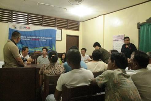
There are some areas, in fact, where fisherfolk can hardly find any fish now, Sacon of the Makaas Fishers Association (MFA) told representatives of the United States Agency for International Development (USAID) during a consultation meeting held in a courtroom here Dec. 10.
Because they use motor boats powered by fuel gas, pursuing fish in deep waters has made the operation expensive and driven fish prices up, said Dario Mutrel, another MFA member.
Fishers here use gill nets and multiple hook and line fishing in waters near the coast line.
During the consultation meeting, Gregory Beck, USAID Deputy Assistant Administrator for Asia Bureau, told the 63-member MFA that his team was trying to get a better grasp of the community’s priority and “to understand where we can be a most helpful partner.”
“You don’t stand alone,” he assured the fisherfolk.
The MFA has been part of the Ecosystem Improved for Sustainable Fisheries (ECOFISH) project of the Bureau of Fisheries and Aquatic Resources (BFAR), which includes municipal fisherfolk registration using TV white space technology. USAID supports ECOFISH.
TV white space refers to frequencies allotted for broadcasting service but not used locally and could be freely accessed, said Lawrence Ang, private-public partnership specialist who demonstrated how the technology works in relief operations and coastal marine management to Beck’s team.
This technology has also been used by local residents and officials in Bohol to exchange information on relief and rehabilitation efforts.
ECOFISH aims to improve the management of coastal and marine resources and associated ecosystems that support local economies on the Danagon Double Barrier Reef through biodiversity conservation, enhancement of ecosystem productivity, and restoration of fisheries profitability, Rebecca Guieb, USAID governance and coastal marine management specialist, said.
The Danagon Double Barrier Reef, a marine key biodiversity area, spans Bohol, Cebu, Leyte, Southern Negros Occidental and Surigao.
Although it suffered major damage in the quake, Tubigon, a transshipment site for the northern part of Bohol, is now on the “recovery phase,” Mendana said.
Of the 128 families in the evacuation center, only 26 remain, awaiting possible relocation, he said. The others have gone back to their normal activities before the tremor.
While the volume of traffic for the tourism sector has dropped, market operation has resumed 75 percent, Mendana said.
Irrigation facilities in this town were also “substantially damaged” by the earthquake, Mendana said, but “small impounding projects to develop the flatlands” cushioned the impact of the tremor’s effect on agriculture here.
Of the 63 MFA members, 28 are also engaged in cultivating rice as tenant farmers.
On top of the myriad changes in their lives, residents have had to cope with altered land elevation and its effects.
Mendana, an engineer, said some of the town’s islands are now “flooded during high tide by 1.4 meters,” while some islands are now “fully flooded during high tide,” a phenomenon he attributed to the “upliftment” of some land areas in Maribojoc and Loon towns, and the “subsidence” in the land elevation here after the tremor.
In Punta Cruz, Maribojoc, sources from the Mines and Geosciences Bureau noted the “upliftment” of the coastal area there by at least 1.5 meter, drying up what used to be a seabed with shellfish and corals.
“Now we have to walk some 100 meters to reach the sea, and we now get direct to the dive site,” Punta Cruz barangay chairperson and resort operator Lourdes Endo said in an interview. “I miss the waters around here.”
Since the seawater near the shore is gone, “shellfish gathering” has become a thing of the past in that part of Bohol, Maribojoc executive chief of staff Oscar Valles, told Beck’s team in a briefing Dec. 9 at the town hall.
Shellfish has been an important support and protein source for those living near the shores of Maribojoc and other Bohol towns.
“When fishers have a small catch, they gathered shellfish on the seashore before getting home to add to their income,” said San Vicente, Maribojoc, councilwoman Artemia Puhiyo, whose husband’s artificial reefs made of stone were damaged by the quake.
(VERA Files is published by veteran Filipino journalists taking a deeper look into current Philippine issues. Vera is Latin for “true.”)