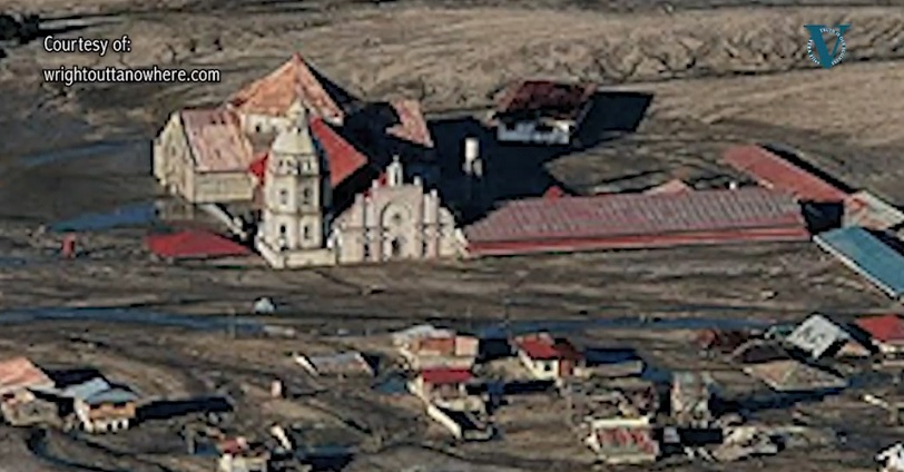
San Guillermo Parish Church: bottom half is buried under six meters of lahar
When the
townsfolk of Bacolor attend mass at the
San Guillermo Parish Church, they enter the worship place through the upper
windows. They have been doing that the past 28 years since Mt. Pinatubo erupted
and altered their lives in ways they never imagined.
The San Guillermo Parish Church, originally built in 1576, stands just off the main highway linking Bacolor town to the rest of Pampanga province.
Rebuilt in 1886, the structure is now literally half of its previous glory.The church’s bottom half is buried under six meters of lahar that swallowed the town and most of the province. It still serves the town’s faithful who access the building through what used to be second windows converted into doorways.
“All of Bacolor is buried under lahar especially the downtown area where the church is,” says Renato Solidum, chief of the Philippine Institute of Volcanology and Seismology.
Solidum was already serving the agency when Mt. Pinatubo woke up from her 500-year slumber in 1991 following a 7.7 magnitude earthquake that shook northern parts of the country a year earlier.
On June 15, 1991, the afternoon sky turned pitch black as ash, rock and other volcanic material were ejected into the sky.
On the same day, Typhoon Diding (international name Nunya) crossed 75 kilometers northeast of Pinatubo. While considered by meteorologists as a minimal typhoon, Diding nonetheless dispersed volcanic ash all over Luzon and as far as the middle of the Pacific Ocean and mainland Southeast Asia.
After Pinatubo heaved her final explosion, survivors of her wrath emerged from their homes and sanctuaries to a world coated by or buried deep under meters of gray volcanic ash.
The eruption of the then little known volcano destroyed or damaged houses, farmlands and infrastructure and claimed the lives of dozens of people and displaced hundreds of thousands of families. It was one of the world’s largest volcanic eruptions in the past century, geologists say.
Jolts and ash fall
“We thought the morning after the eruption it was all over. Then we realized it was only just the beginning because of the lahars that came every year,” said local historian Robert Tantingco, director of the Kapampangan Studies in Holy Angel University.
When Pinatubo erupted, it spewed out 7-10 cubic kilometers of ash that blanketed areas as far away as Manila in a coat of fine, gray ash.
Much of that was dumped on the slopes of the volcano. Pyroclastic flows easily overran the slopes of Pinatubo, engulfing gullies as deep as 200 meters.
The Aeta tribes that lived on the slopes lost their entire world. The mountain and centuries-old forests they knew were wiped out and replaced by a barren and unfriendly place.
The US Clark Air Base located several kilometers from Pinatubo was abandoned after it was buried in volcanic ash. The American military eventually closed the installation.
While residents were forewarned of the eruption, nobody knew what to expect.
“What I imagined was Mt Mayon. We will watch it from afar. We would watch a trickle of glowing lavas and we will take pictures from a safe distance,” recalled Tantingco, who was then 31 years old.
He was wrong.
Tantingco was at the family home in Mabalacat town when the sky turned dark around noontime on June 15, 1991. Pinatubo had finally erupted, ejecting a column of ash and other materials up to 34 kilometers into the air.
“I was bewildered by it,” he recalled. “I could hear the mudflow in the brook near our house. It was not the usual splashing water; it was something heavy, something sinister.”
The darkness went on and on even as Typhoon Diding pummeled the roof with rain and then, later on, with rocks and other volcanic debris.
Earthquakes shook the ground every few minutes, exponentially adding to the anxiety of those in the vicinity.
“We were huddled together like frightened animals, crying…Of all the things that frightened us that night, it was the earthquakes,” Tantingco said.
“It was continuous. They were hard jolts. I realized (later) it was because of the falling rocks, collapsing rocks from the crater, the rim of the volcano.”
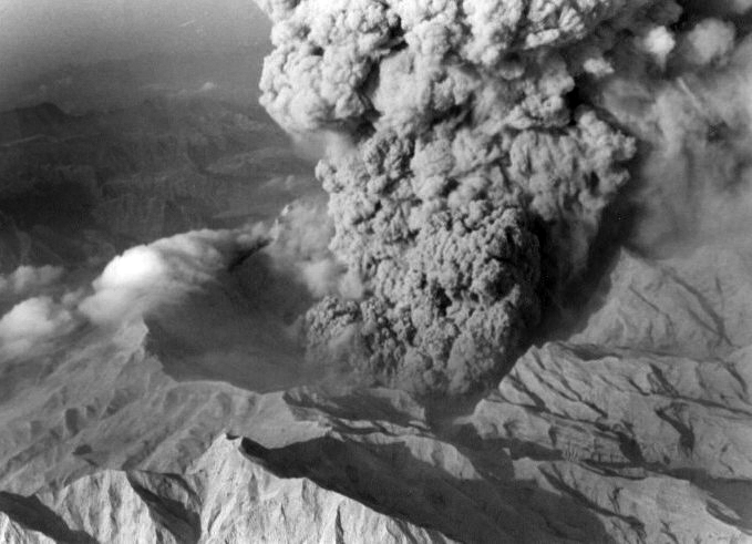
Mt Pinatubo eruption in June 1991. File photo from Phivolcs.
Like in a twilight zone
There was a frantic flow of vehicle and pedestrian traffic away from the area that night.
People were fleeing because of fears of a nuclear explosion from the nearby Clark air base. There were also unfounded rumors in the radio that “Pinatubo was spewing so much material that it was emptying the underground, that whole province would collapse.” Another version of the story was that “there was a fissure or a crack on the slope of the mountain that will cause a slide, a massive landslide that will bury the province.”
“I honestly felt I was going to die,” Tantingco said.
“And then sometime during the night, things just started getting weird because the sound was already muffled. You can’t hear anything,” he said. “The ash fall was so thick the soundwaves could not penetrate the wall of ash fall. Everything was quiet. You could not hear the rocks fall on the roof because there’s a layer of ash.”
“Then the orange, red, green flashes of lighting crossing the sky, then the earthquakes, Tantingco continued. The general feeling that you’re in the Twilight Zone.”
The next day, the sun came out and the ground stopped shaking.
“I waited patiently for daybreak. And when it finally came, everything was grey, everything was destroyed,” the historian narrated.
He stepped out of the front door to an empty neighborhood heavily dusted with volcanic ash. Not long afterward, a friend came over; they only had hugs of relief for each other.
“It had been a traumatic night and the only response was to cry. It was the first time that I cried.”
Tantingco stayed in the family home by himself after his family evacuated to Baguio City, about 155 kilometers away, shortly after the eruption. Eventually his father came home, and then his mother. After a while, even the little ones came home.
Life was never the same after that fateful day. Despite that, the Tantingcos stayed, along with most Kapampangans.
They all adapted to life after a night of what seemed like the Apocalypse every time the lahars charged down to the lowlands whenever it rained.
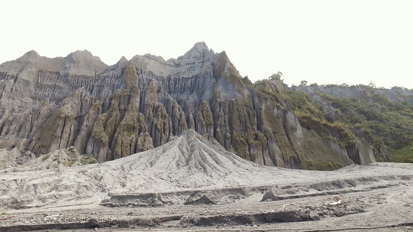
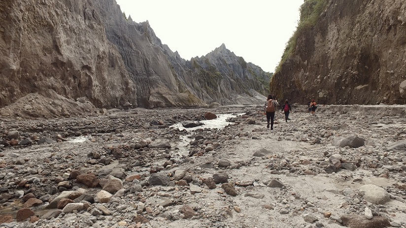
Ash from Pinatubo now forms the wall of the gorge on Tarlac River. This demonstrates how much volcanic material remains on the slopes of the volcano, which continues to pose a possible threat to low-lying areas. Photo by Terence Gonzalves.
Landscape changed by lahar
Lahar is a rampaging slurry of thick debris – pyroclastic material and ash – and water washed down by the rain from the slopes of Pinatubo. The lahar is then delivered to lowland towns and cities through rivers originating from the volcano – the Tarlac, Sacobia-Bamban, Abacan, and the Pasig Potrero Rivers.
Lahar flows buried half of the San Guillermo Parish Church as well as the Bamban Bridge in the North Luzon Express.
“Immediately after the eruption, you can see the smoother slopes of the volcano because river valleys were covered,” Solidum, the country’s chief volcanologist, said.
“In satellite images you can actually see the difference. Before the eruption you can see rough surfaces in the slopes of the volcano and then after, you see smooth because of these thick deposits.”
Unfortunately, the lahars didn’t stay on the slopes. In the years following the eruption, seasonal monsoon rains eroded lahar deposits and carried them down to the low lands – Pampanga, Tarlac and Zambales.
The lahars follow the path of the river systems. The provinces of Tarlac and Zambales were relatively lucky compared to Pampanga, where the rivers were circuitous and wound around population centers.
“(Lahars) go towards the sea. And the path towards the sea – which is Manila Bay for Pampanga – is circuitous,” Tantingco said. “Here in Pampanga, rivulets and rivers and canals were located in the middle of communities – towns, villages, and cities – before emptying into Manila Bay. All of that was buried.”
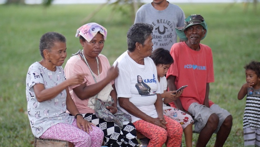
And among Pampanga towns and cities, Bacolor was worst hit. Nineteen out of her 21 towns were buried under lahar. In some areas, only roofs could be seen where a barangay once stood.
Bacolor’s original name was Bakulud, a Kapampangan word meaning high ground. As it turns out, Bacolor is elevated ground precisely because pyroclastic materials from Pinatubo is routinely dumped over the area, piling up over the years.
Regular lahar attacks from Mt. Pinatubo stopped only in 1995. By this time, Bacolor had reclaimed its previous status as elevated land.
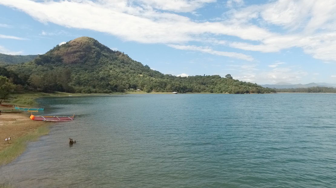
The stillness of Mapanuepe Lake belies the tragedy that it is borne out of. The lake was created when lahars blocked the mouth of the Mapanuepe River, flooding the valley and its settlements. Photo by Terence Gonzalves.
Lakes are formed, rivers diverted
Another phenomenon brought about by lahar flows is the damming of river systems. The mouths of rivulets are essentially plugged, cutting off the tributaries from the main river, flooding the adjacent area, and basically creating a lake because of the absence of drainage.
The most spectacular of these lakes is the Mt Pinatubo crater lake in Botolan town, now a major tourist draw in Zambales.
It was formed after the eruption destroyed the volcano’s original summit, leaving a caldera that eventually filled with water. It is as deep as 600 meters in some points.
These lakes are as much as worry for scientists as rampaging lahars.
A Fact Sheet on Pinatubo issued by the US Geological Services says: “After a few weeks or months, the lakes overtop and quickly erode through their dams, releasing large volumes of water that generate major lahars. Because these large and powerful mudflows can occur without warning, even when there is no rain, they are among the most dangerous of Pinatubo’s lahars.”
“One lake on the Pasig-Potrero River, on the volcano’s east flank, has formed and broken out three times (1991, 1992, and 1994), creating giant lahars that have killed dozens of people,” it said.
Mapanuepe Lake in San Marcelino town is another one of these lakes.
“This was an actual event happening in front of my eyes,” Solidum recalled.
“When the lahar was making the corner or the intersection of the Marella river with the Mapanuepe river becoming shallower, you would see the water going upstream.”
Tributaries are normally shallower than the main river. With the Mapanuepe River heavily silted with lahar, it became shallower.
Eventually the exit to the Marella River got plugged, drowning the adjacent communities. Today, the sole reminder of the former barangay is the church steeple jutting out of middle of the lake.
But while areas like Bacolor and the Mapanuepe Valley were practically erased off the face of the planet, other areas were relatively spared from rampaging lahars. That’s because lahar flows sometimes dam certain rivers thus diverting lahars to other areas.
“They cannibalized each other during the Mt Pinatubo eruption. The alteration of the slopes was so extreme the rivers were diverted one day then they were back the next day,” Tantingco, the local historian, said.
For instance, in 1992, secondary eruptions eroded the partition between the Sacobia and Abacan rivers, diverting all the lahars to the Sacobia River.
“People in the low lands don’t know when the lahars are going to come. One day the lahars are flowing in Sacobia the next day they are flowing in Abacan because they keep cannibalizing each other,” Tantingco explained.
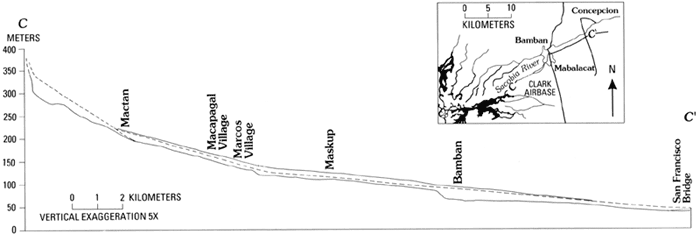
Longitudinal profile of the Sacobia-Bamban River, starting at 350 meters in elevation, 12 kilometers from the summit of Mt. Pinatubo, and extending down to less than 50 meters in elevation. Preeruption profile is shown by the lower solid line; 1991 lahar deposits by the dashed line; 1992 lahar deposit by the upper solid line. Note that vertical exaggeration is 5x and that only the lower, gently-sloping reaches of the Sacobia are shown. Illustration from the US Geological Survey study “Observations of 1992 Lahars along the Sacobia-Bamban River System
Movement of people
All this flooding is because the rivers were heavily silted with lahars initially dumped on the slopes of the volcano and then eroded downstream by the rains.
“The land became higher so that there are areas that get flooded when it didn’t get flooded before the eruption. There are areas where the floods take weeks before they go down,” explained Engr. Art Daag, head of Phivolcs’ geology office.
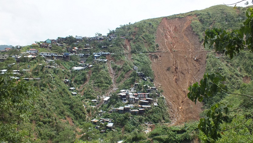
The local governments of Pampanga have since reconstructed land titles for private land especially in population centers.
Some were able to rebuild over the property they lost and pick up almost where they left off. Others – sometimes whole communities – had to relocate to settlements designated by government.
Following the eruption and the lahars, government undertook hazard mapping to determine which areas are safe for habitation. Some of the original settlements now fall within danger zones.
It took many, many years before vegetation returned to Pinatubo but it took the mountain’s original Aeta dwellers decades to come home.
There are Aeta tribes, for instance, already granted titles to ancestral domain and who have reestablished a community up the mountain, continue to live in lowland resettlement communities.
This circumstance is not unique to upland people.
“Now you will find resettlement areas in Mabalacat, a whole town that was not there before. But there are communities of thousands. They never went back,” Tantingco said.
“During elections, for example, the mayor running in Bacolor has to go there (Mabalacat). Geographically they are in Mabalacat but…you will find yourself already in a place populated by non-Mabalacat voters.”
He continued, “They brought with them their own culture, their own community life.”
Ash from Pinatubo now forms the wall of the gorge on Tarlac River. This demonstrates how much volcanic material remains on the slopes of the volcano, which continues to pose a possible threat to low-lying areas. Photo by Terence Gonzalves.
Threat lessened but danger lurks
Pinatubo has gone back asleep since then.
In 1995, a 56-kilometer U-shaped mega dike costing P2.7 billion was built as a catch basin for the Pasig-Potrero River, which has become the main avenue for the lahars.
The mega dike, however, claimed more victims when a section of the dike collapsed, drowning three towns and resulting in a loss of P38.9 million for the government.
The last bad lahar flow was in 1998 but overall, residual threats from the last eruption are low.
But neither Pinatubo nor her immediate environs had gone back to their state pre-eruption.
“The landscape that we Kapampangans were familiar with for the last 300 years of our existence was disturbed and changed forever. Only to realize that this has been a cycle throughout the eons and years of history and prehistory,” explained Holy Angel University’s Tantingco.
Studies undertaken immediately prior to the eruption showed that Pinatubo, in previous eruptions, dumped enough pyroclastic material to completely change the face of the land.
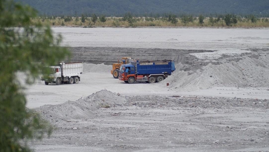
Remnants of prehistoric eruptions are evident in what is known as Porac sand – fine sand popular in the construction industry and found abundantly and quarried openly along Pampanga’s riverbeds.
Quarry operations contribute as much as P40 million daily to the province’s earnings and employing thousands of locals.
The rich supply of sand from Pinatubo’s slopes could last at least another 30 years, said Art Punsalan, chief of Pampanga’s environment office.
He acknowledged that the riverbeds are not as silted as before, and they need heavy rains to wash down these deposits downstream.
This is not the case outside Pampanga, however.
“In Zambales, you still have a lot of rivers in the upper portion filled up with ash or lahar,” Solidum noted. “So there is still potential for lahar occurrences if in case there is extreme rainfall in the Pinatubo area.”
“The threat has been lessened, but it’s still there.”
(This story is produced by VERA Files under a project supported by the Internews’ Earth Journalism Network, which aims to empower journalists from developing countries to cover the environment more effectively.)