
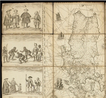

LOOKING at the almost 300- year-old Philippine map by Fr. Pedro Murillo Velarde which businessman Mel Velarde acquired for P12 million in an auction in London last year, one can see that the Jesuit priest is a great storyteller.
The 1734 Murillo map shows more than just locations. It has two panels on both sides engraved with images depicting lifestyles and special features of places. One panel shows a farmer plowing the field not far from a river with crocodiles. It’s noted that in Zamboanga, there’s “Pozo de Agua Dulce.” In general it showed Filipinos enjoying a highly civilized society.
But the most significant feature of the Murillo Velarde map is a tiny spot off the shores of Nueva Castilla, which was then the name of Luzon labeled “Panacot.”
It’s a coral reef known now as Scarborough shoal, after the tea-carrying British boat Scarborough sank in the vicinity in 1784.
It is also known as Bajo de Masinloc (shoal of Masinloc). Fishermen refer to coreal reef, 124 nautical miles off Zambales, as Panatag. The Chinese which also claims the shoal, which is 467 nautical miles from its mainland calls it Huangyan Island.
I’m intrigued by Fr. Murillo’s identification of the coral reef a “Panacot”, which means fear in contrast to how the fishermen refer to it as “Panatag” which means calm.
Could it be that it was called “Panacot” because any one who ventured into the shoal would have to go through rough seas? Masinloc fishermen, on the other hand, say that they called the rock formations Panatag because it provides them a solid refuge during bad weather.

Mel Velarde, president and CEO of the Information Technology based- Now Corp and chairman of the Asian Institute of Journalism and Communication, has decided to donate the map to the National Museum since the government has no funds to buy it from him.
The map is still being stored in the vault of the auction house Sotheby’s in London. It will be used as one of the pieces of evidence to debunk the claim of China that they own a almost the whole of the South China Sea, including Scarborough shoal, with its nine-dash line map.
How the map by a Jesuit priest in Manila got to London and became part of the collection of the Duke of Northumberland who owns the magnificent Alnwick Castle is another interesting story.
The British forces who invaded the country in 1762 engaged in widespread looting of churches and government offices.
Historian Renato Perdon said Brigadier General William Draper, commander of Brtitish land forces, “brought to London some Spanish flags and eight copper plates which printed the celebrated Murillo Velarde Map of 1743. He donated the Spanish flags to his alma mater, Cambridge University. The copper-plates were used for some time to print copies of the Murillo Velarde Map which were sold to public libraries and cartographic collectors. One such copy was purchased by the Library of Congress, Washington, D.C.”
The Murillo Velarde map had lain together with hundreds of heirlooms collected by the Duke of Northumberland for more than 200 years in Alnwick Castle, a favorite location for period films. In the first two Harry Potter films, the castle was the Hogwarts School of Witchcraft and Wizardry.
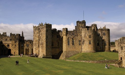
It happened that three years ago the Northumberland County was hit by heavy rains that destroyed a culvert of the Alnwick Castle and caused severe flooding not only to the Duke’s property but also the surrounding community.
To recoup the millions that he spent for the repair of the property, the current Duke of Northumberland, Ralph George Algernon Percy, decided to auction off 80 family heirlooms which included the Murillo map.
That’s how the Murillo Velarde map was acquired by Mel Velarde.
Velarde has bought a large format printer to reproduce the map. The first copy will be presented to President Aquino on Friday as the nation celebrates Independence Day.
He would like to distribute copies of the maps to schools and in the provinces through local government units to rekindle the sense of patriotism among the young people.
“I’m also proposing a stone etch of the map in front of the Jose Rizal monument (in Rizal Park),” he said.