
Editor’s Note: This story was updated on Feb. 14, 2025 to add Republic Act No. 12064 in the citation of the WPS definition.
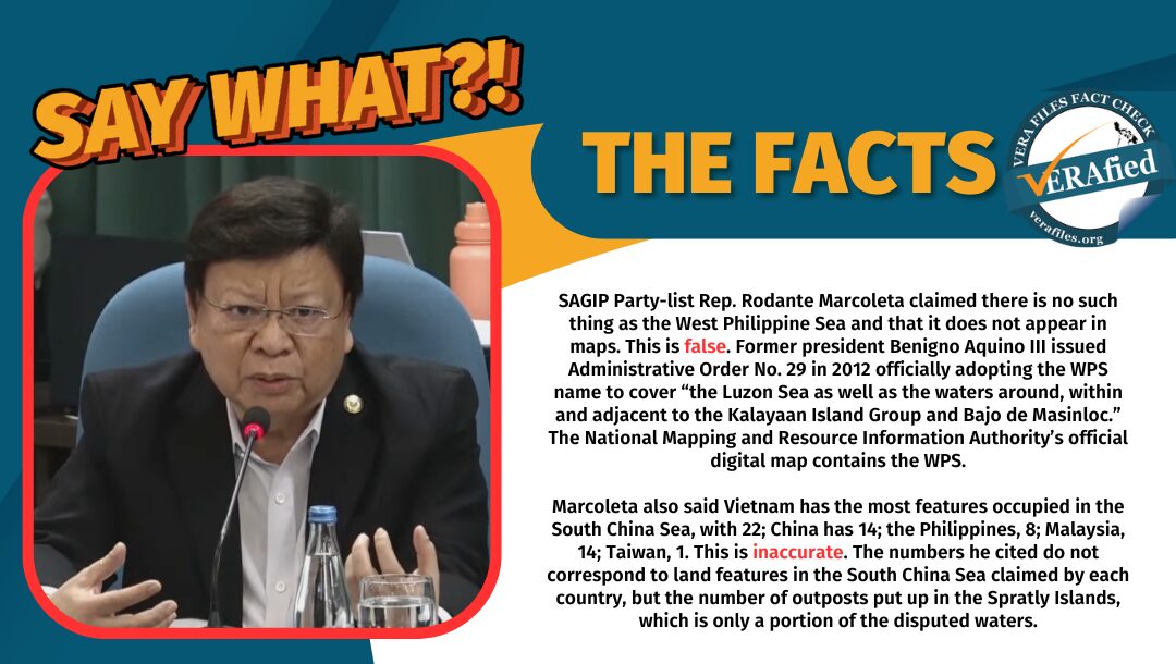
SAGIP Party-list Rep. Rodante Marcoleta claimed “there is nothing (sic) as West Philippine Sea,” saying the area does not appear in local maps as it merely refers to the country’s exclusive economic zone (EEZ) in the South China Sea. He also cited the number of land features built in the area by different claimants in the disputed waters.
This is false and inaccurate. Contrary to Marcoleta’s statement, the West Philippine Sea (WPS) is recognized in official Philippine documents and maps.
The figures he cited are outdated and incorrect as they represent only the number of outposts in the Spratly Islands, which is just a portion and not the entire South China Sea.
STATEMENT
During a joint inquiry by three committees of the House of Representatives on the spread of disinformation last Feb. 3, Marcoleta lamented that the government is not doing enough to explain issues to the public. He criticized an example presented by Rep. Dan Fernandez, chair of the Committee on Public Order and Safety, saying:
“Isipin po natin, sir, ah, there is nothing as West Philippine Sea. Wala po ‘yon; that is a creation by us. Sa totoo lang po, kahit na basahin mo pa ang ating mapa or what, there is no West Philippine Sea. Ang West Philippine Sea, ‘yan po ‘yung area na kine-claim natin, ito ‘yung exclusive economic zone.”
(If we think about it, sir, there is no such thing as the West Philippine Sea. That is nothing; it is a creation by us. To be honest, even if we read our maps, there is no West Philippine Sea. The West Philippine Sea is the area that we are claiming, this is the exclusive economic zone.)
He continued:
“Ang sinasabi po, ino-occupy daw ng China ‘yung ating territory. Sir, sa totoo lang po, if CICC (Cybercrime Investigating and Coordinating Center) and other agencies would cooperate with one another to empower our people, to educate them all, wala pong made-deceive, kahit ano pang gawin ng China. Kasi alam po na– we are all claimants dito po sa panig ng South China Sea. Several of us: Philippines, China, Vietnam. Hindi po natin alam na ang Vietnam has the most features occupied in the South China Sea. They have 22. China is 14. Tayo, walo. Malaysia, 14. Taiwan, one.”
(It is being claimed that China is occupying our territory. Sir, in all honesty, if the CICC and other agencies would cooperate with one another to empower our people, to educate them all, nobody would be deceived regardless of what China does. Because they would know that we are all claimants to the South China Sea. Several of us: Philippines, China, Vietnam. We don’t even know that Vietnam has the most features occupied in the South China Sea. They have 22, China [has] 14. We have eight. Malaysia, 14. Taiwan, one.)
Source: JOINT COMMITTEE HEARING (CPOS, ICT AND PUBLIC INFORMATION), Feb. 3, 2025, watch from 3:13:01 to 3:14:18
Commodore Jay Tarriela, Philippine Coast Guard’s spokesperson for WPS matters, posted on X (formerly Twitter) on Feb. 4, describing Marcoleta’s claim a “disservice” and an “embarrassment.”
On Feb. 10, Marcoleta shot back at Tarriela on One News, this time correctly clarifying that the WPS is not on any world map. He said:
“Huwag tayong magpakagago at magpakaignorante katulad ng commodore [Tarriela] na ‘yun. Hindi pala niya naiintindihan na hindi pa siya nakasulat sa maps ng mundo, ng karagatan.”
(Let us not fall for the foolishness and ignorance of that commodore [Tarriela]. I don’t think he understands that [the WPS] is not in any maps (sic) of the world, of the oceans.)
Source: News and Views Livestream | February 10, 2025, Feb. 10, 2025, watch from 31:49 to 31:59
FACT
The WPS is codified in the government’s official documents and is based on the United Nations Convention on the Law of the Sea, which states that member-countries are entitled to an EEZ spanning 200 nautical miles from their shorelines.
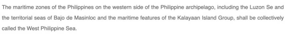
Former president Benigno Aquino III issued Administrative Order (A.O.) No. 29 in 2012 officially adopting the WPS name to cover “the Luzon Sea as well as the waters around, within and adjacent to the Kalayaan Island Group and Bajo de Masinloc, also known as Scarborough Shoal.”
The same definition of the WPS is carried in Republic Act No. 12064, or the Philippine Maritime Zones Act, signed in November 2024.
In line with A.O. 29, the National Mapping and Resource Information Agency (NAMRIA) was tasked to include the WPS in official maps as illustrated in its digital eMapa, and an information campaign was launched to make the public aware of this.
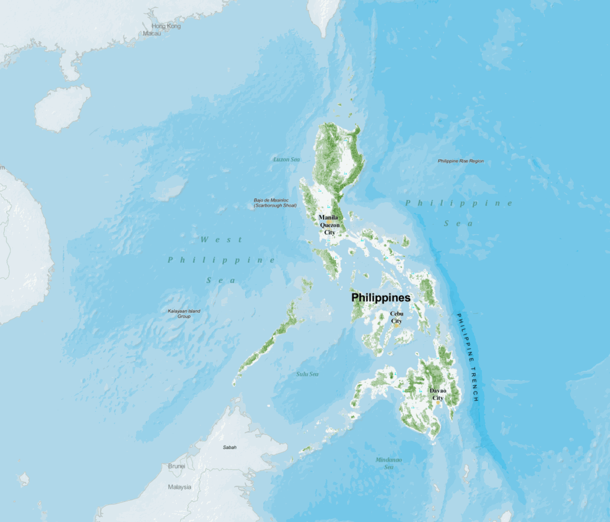
However, NAMRIA, the Department of Foreign Affairs and other relevant government agencies have not deposited with the United Nations (UN) a copy of A.O. 29 “enclosing the official map reflecting [WPS]” as directed by Aquino in the document. As a result, WPS does not appear in international maps as the name has not been adopted by the UN and recognized by other countries.
The numbers Marcoleta cited also do not correspond to land features in the South China Sea but the number of outposts built in the Spratly Islands.
Outposts are structures, whether military or civilian in nature, that have been individually and separately constructed by parties in the six-way dispute in some areas of the South China Sea to strengthen their claim.
David Shear, former United States assistant secretary of defense for Asian and Pacific Security Affairs, said in a 2015 U.S. Senate hearing that Vietnam had 48 outposts, the Philippines and China each had eight, Malaysia had five and Taiwan had one.
According to the Asian Maritime Transparency Initiative, China has since increased its outposts to 27 and the Philippines to nine. Vietnam’s outposts range from 49 to 51 since the status of some construction projects remains unclear.