
By ELLEN T. TORDESILLAS
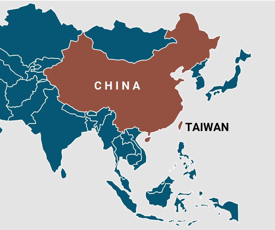
THE Republic of China (ROC) or Taiwan has its issue with mainland China (PROC-People’s Republic of China) but in matters of ownership of almost the whole of South China Sea, they have the same line.
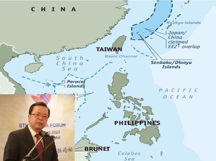
In the statement released by Taiwan Tuesday, it asserted that Nansha islands also known as Spratly Islands; Shisha (Paracel) islands, Chungsha Islands Macclesfield Bank) and Tungsha (Pratas) Islands, as well as their surrounding waters, are an inherent part of ROC territory and waters.
“As the ROC enjoys all rights to these island groups and their surrounding waters in accordance with international law, the ROC government does not recognize any claim to sovereignty over, or occupation of, these areas by other countries, irrespective of the reasons put forward or methods used for such claim or occupation,” the statement said.
Some 80 percent of the vast South China Sea) is claimed by China, Taiwan and Vietnam. Some parts of the SCS are also claimed by the Philippines, Vietnam and Brunei. Many of the claims are overlapping.
Of the 750 features – reefs, shoals, rocks- in the South China Sea, Vietnam occupies the most number: 22. The Philippines occupies nine; China, eight; Malaysia, four; and Taiwan, one. Brunei is the only SCS claimant that does not occupy any shoal or reef.
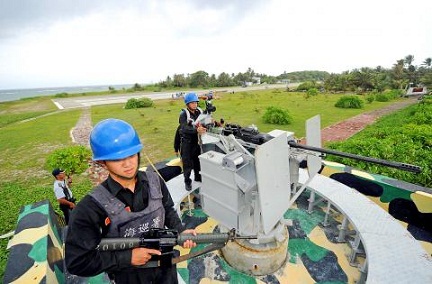
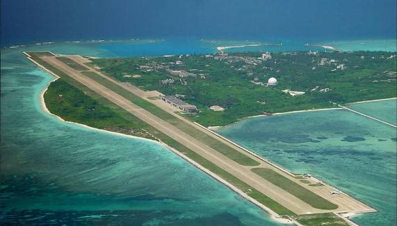
Taiwan occupies the biggest feature known as Itu Aba. The Chinese name is Taiping. Philippine name is Ligao.
Although it is occupied by Taiwan, with whom the Philippines has a good economic and cultural relations, Itu Aba was mentioned in the Memorial because the Philippines has a One-China policy that recognizes the Beijing government as the representative of the Chinese people.
Under the One-China policy, Taiwan is a province of China.
Not to mention Itu Aba would be tantamount to agreeing that it belongs to the Chinese people.
There was another matter concerning Itu Aba that became a contentious issue between then Solicitor General Francis Jardelesa, now Supreme Court Associate Justice and the Philippine legal team headed by Washington-based Paul Reichler.
Jardeleza was of the view that including Itu Aba in the Memorial would weaken the Philippine case because the island has a water source and can sustain human habitation therefore entitled to exclusive economic zone.
The legal team however said it is just a small atoll consisting of tropical reef covered with sandy coral and shell and cannot sustain human habitation. A military ship services the “island.”
As a compromise the Philippine team agreed to mention Itu Aba in the memorial but it was not included in the features that it asked the Arbitral Court to rule on.
In its statement, Taiwan said: “Taiping Island (Itu Aba), the largest (0.5 square km) of the naturally formed Nansha (Spratly) Islands, has been garrisoned by ROC troops since 1956. In the same year, the ROC government established the Defense Zone of the Nansha (Spratly) Islands on Taiping Island (Itu Aba). In February 1990, by executive decree, the Executive Yuan (Cabinet) of the ROC put Taiping Island (Itu Aba) under the administrative jurisdiction of Qijin District of Kaohsiung City. For the past six decades, ROC military and civilian personnel have dwelled on Taiping Island (Itu Aba), conducting their respective missions while making use of and developing its natural resources.
“Taiping Island (Itu Aba) has groundwater wells, natural vegetation, and phosphate ore and fishery resources. Moreover, personnel stationed on the island cultivate vegetables and fruit and rear livestock. In 1959, personnel built the Guan Yin Temple, dedicated to the Bodhisattva of Compassion. From legal, economic, and geographic perspectives, Taiping Island(Itu Aba) indisputably qualifies as an “island” according to the specifications of Article 121 of the United Nations Convention on the Law of the Sea (UNCLOS), and can sustain human habitation and economic life of its own; it is thus categorically not a “rock”. The ROC government will firmly defend this fact. Any claims by other countries which aim to deny this fact will not impair the legal status of Taiping Island (Itu Aba) and its maritime rights based on UNCLOS.”
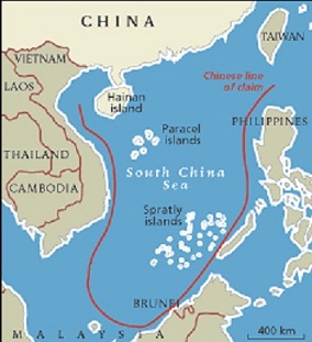
The nine-dash line map which the Philippines is asking the U.N Arbitral Court to invalidate originated with ROC.
Taiwan’s statement touched on the map: “The South China Sea islands were first discovered, named, and used, as well as incorporated into national territory by the Chinese. In 1938 and 1939, Japan illegally occupied the Tungsha (Pratas), Shisha (Paracel), and Nansha (Spratly) Islands. On March 30, 1939, Japan integrated what it called “Shinnan Gunto” (comprising some of the Nansha (Spratly) Islands) into Takao Prefecture (today known as Kaohsiung City) through Announcement No. 122 of the Taiwan Governor-General’s Office. In 1946, following World War II, the ROC government reclaimed the Tungsha (Pratas), Shisha (Paracel), and Nansha (Spratly) Islands, erecting stone markers on major islands and garrisoning some.
In December 1947 it issued the revised names of the South China Sea islands and the Location Map of the South China Sea Islands, which delineate the scope of ROC territory and waters in the region.”
The map had 11- dashed lines. Much later, after an upheaval in China that pushed the ROC out of the mainland to Taiwan, the Beijing government removed the two dots reducing the dashed line to nine.
Taiwan said they are willing to work with other parties concerned to jointly ensure peace and stability in the South China Sea, as well as conserve and develop resources in the region.