Text and photos by ELIZABETH LOLARGA
 IF Dr. Alfredo Mahar Francisco Lagmay, executive director of the Nationwide Operational Assessments of Hazards (NOAH), had his way, politics would be outlawed in disaster work.
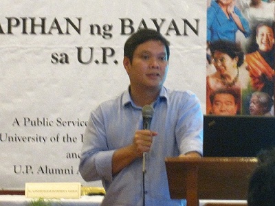
Speaking at the University of the Philippines Alumni Association’s “Kapihan ng Bayan sa UP,” he said local officials and their communities must realize the lessons from the recent typhoons, unrelenting rains and thunderstorms in an archipelago vulnerable to calamities.
He said flash floods could happen in a matter of seconds and kill, adding that these did not even have to rise above the head to kill. What’s needed at all times even before a typhoon approaches is, he said, accurate, timely information so people can save their lives and not be caught unaware.
Lagmay, a graduate of UP’s National Institute of Geological Sciences and Cambridge University, said, “Awareness is the first step to preventing disaster.”
He told the UP community that their best work must not sit on shelves. “If we put them into operation, we can do wonders. We have had successes. We can replicate them in years to come.”
He cited the Aug. 19-21 habagat rains wherein the Philippine Atmospheric, Geophysical and Astronomical Services (PAGASA) instrument in Subic, Zambales, recorded that most of the rains ended up in Cavite and Metro Manila. These came from the mountains of Bataan where there are two volcanoes.
He said it was somehow a good thing that these rains were mainly dumped in Manila Bay, thus preventing further flooding. When the NOAH staff studied the PAGASA instrument’s pictures, they saw lots of rain clouds over Mt. Mariveles, the clouds playing an important role in dumping rainwater. He and the staff did a “what if?” scenario: without the province’s volcanoes, would there have been lesser rain?
The rains during those days were 125 percent more than the accumulated rainfall for the months of August and September. A PAGASA station in Sangley tracked how the rains came down from the northeast towards Cavite and the Bay. Had they not gone down in that direction, they would’ve been dumped all over Metro Manila.
Lagmay stressed that “this information should be out at the soonest time” to avoid disaster problems that Filipinos know only “how to treat after they fact, after they have happened.”
He said NOAH exists so people, including PAGASA’s staff, would know what to expect. He decried how “LGUs don’t know what’s happening. I call PAGASA to get the critical information and warning out. During a disaster, it’s chaos. PAGASA can’t handle all the calls.”
Which is why NOAH uses social media (Facebook, Twitter) to inform people. The old model of using knowledge to withhold information from people in order not to cause panic is passé. When NOAH was being set up, many people had to be fired because they held on to the old model of keeping information to themselves.
Lagmay added. “Give the information to them; it’s their right, it’s their lives! This is the information that involves the rich and the poor. The information involves taxpayers’ money. If they have the information, they will not panic.”
He gave Typhoon Pablo that crossed Mindanao last year as an example of early warning. Lagmay said, “Before it hit, people were warned as early as 1 p.m. They had two to three hours lead time to leave.”
Public officials didn’t want a repeat of Typhoon Sendong’s devastation in 2011 in Cagayan de Oro and Iligan cities. He said, there were few deaths or no deaths after Sendong, but this fact doesn’t get media coverage.
He said preventive measure enable “people to know where to go in times of disaster, during times when it happens and months before it happens. We must get people not to develop structures in areas where they shouldn’t be building. Disasters are linked to man made actions, to human errors. Otherwise, these are just natural hazards. Development shouldn’t happen in compromised areas.”
NOAH operates under President Aquino’s order to improve weather forecasting through at least a six-hour early warning about floods. Lagmay said 800 sensors have been installed in strategic places in the country. Within 10 to 15 minutes, a scientist looking at them can see where it’s raining light, hard or heavily.
He defined torrential rainfall simply, saying, “It’s when you cannot see the road even if the windshield wiper is set at its fastest.”
The technique, he said,is to translate torrential rains into something people can understand. No amount of science and technology is good if people don’t understand.”
NOAH is surveying rivers to see where houses and informal settlements are. Lagmay said these flood maps raise awareness that’s good for development planning: where to base search-and-rescue boats, where safer relocation sites are, what and where to plant or what’s known as “smart agriculture.”